The desert isn't built for water. That was the immediate thought across the United Arab Emirates last week as a deep trough over Egypt pushed a severe weather system into the region. Starting March 23, 2026, United Arab Emirates braced for instability, but the intensity exceeded standard forecasts. Residents watched their phones buzz with alerts while rain hammered skylines normally reserved for dust storms. The situation turned dangerous quickly, forcing authorities into emergency mode as waters rose faster than drains could handle them.
Record-Breaking Rainfall Metrics
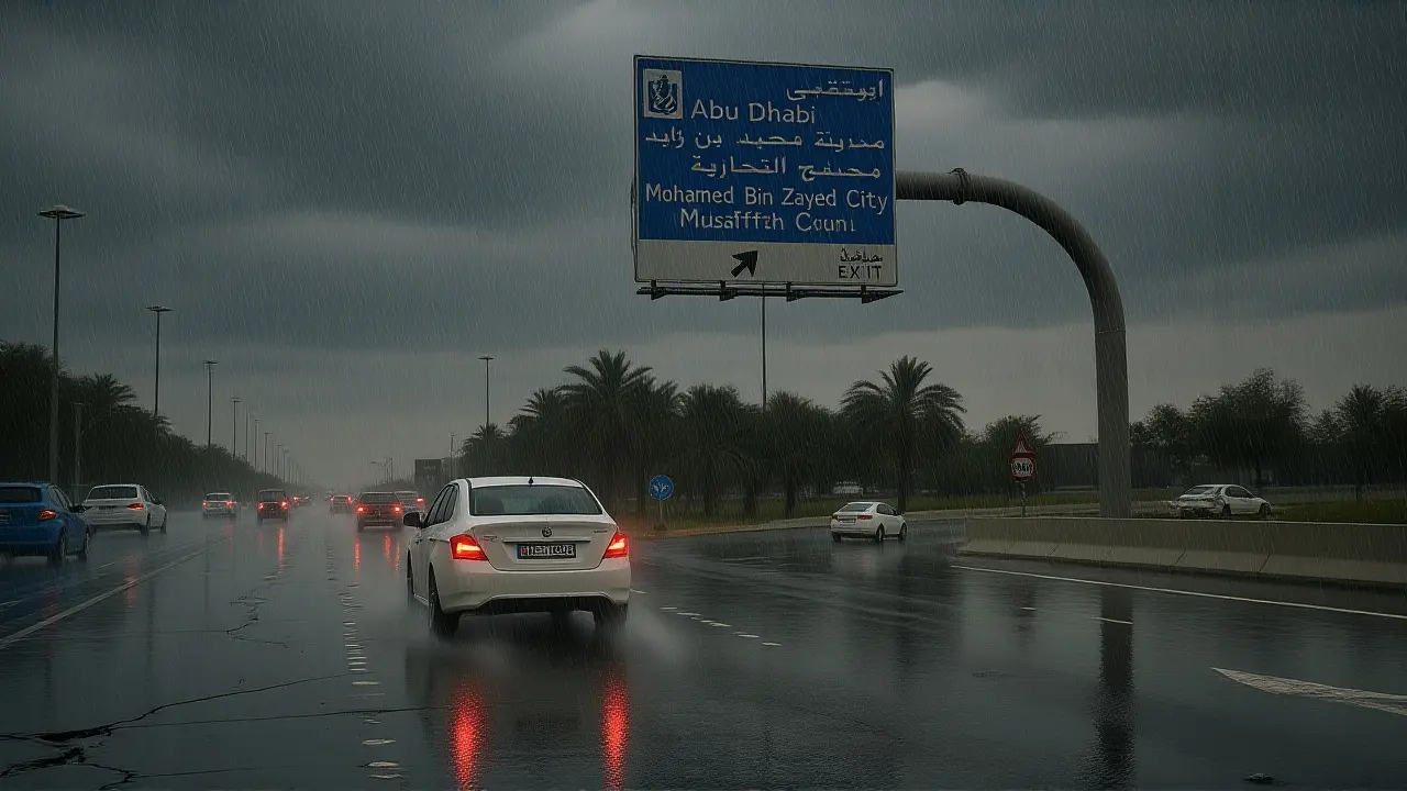
The numbers tell a stark story. On Monday, March 23 alone, several locations saw precipitation that would take months in typical years. In Ajman, Al Manama recorded 93.3mm of rain in a single day. Not far away, Ghayathi in Al Dhafra logged 91mm. It wasn't just isolated pockets; Mohammed bin Zayed City hit 78.7mm. For context, Dubai typically receives about 100mm annually. This means some districts received their entire yearly quota in roughly 48 hours.
Forecasters were quick to adjust expectations. The National Center of Meteorology, often called NCM, issued multiple updates stating totals could range between 100 to 500 millimetres by March 28. While shocking, it hasn't beaten the record set during the historic April 16, 2024 floods, when Khatm Al Shakla recorded 254mm in under 24 hours. Still, this event highlights how rapidly weather patterns are shifting. It's a reminder that even in arid climates, the hydrology cycle can turn aggressive in short bursts.
Emergency Protocols and Public Safety
Safety became the priority immediately. The Ministry of Interior urged citizens to stay off roads during active downpours. Authorities activated speed reduction systems on key arteries like Abu Dhabi's Al Khaleej Al Arabi Road, capping speeds at 100 km/h. This isn't just bureaucracy; it's damage control. Wet asphalt combined with high winds creates slippery surfaces, and the wind gusts themselves were a hazard, reaching speeds of 55 km/h near sand deposits.
In Ras Al Khaimah, officials specifically warned drivers to avoid flooded zones. Ajman Municipality confirmed crews were working 24/7 on drainage management. They knew the risks of flash floods in wadis and valleys, where water flows gain momentum fast. One wrong decision behind the wheel could lead to being swept away. The advice was simple but firm: stay home, keep first aid kits ready, and monitor official channels constantly.

Unstable Weather Timeline and Forecast
The timeline for this UAE Severe Weather Event 2026United Arab Emirates stretched nearly six days. Initial warnings went out on March 24, citing cumulus clouds and potential hail. By Thursday evening, March 26, the final wave moved west to east, hitting Al Dhafra before rolling through Abu Dhabi and northern regions. Forecasts indicated skies would gradually clear by Saturday, March 28, though visibility remained low due to blowing dust. Temperatures dropped significantly, creating a noticeable chill alongside the moisture—something rare for late March in the Gulf.
Experts noted this wasn't a singular event. The system involved both surface and upper-air low-pressure interactions. It's complex meteorology that forces unstable conditions to persist. Neighboring countries like Qatar, Iran, and Iraq felt the ripple effects too. The shared geography means when the weather turns, the border lines rarely stop the rain. As cleanup began, the focus shifted to assessing infrastructure damage and reviewing drainage capacity for future seasons.

Why This Matters Now
This weather spike forces a conversation about climate resilience in desert nations. With temperatures already spiking elsewhere globally, extreme winter and spring variability is becoming common. The economic impact involves transport delays, agricultural planning adjustments, and insurance claims. For the average resident, it changes daily habits. You check the app before leaving the house, just in case. The infrastructure is modern, but nature still moves faster than concrete.
Frequently Asked Questions
How does this affect local commuters?
Commuters face reduced visibility and higher accident risks. Roads may flood quickly, especially in valleys and depressions. Drivers are advised to lower speeds to 100 km/h on highways and avoid routes known for poor drainage to prevent stalling in standing water.
What led to these specific weather conditions?
A deep trough over Egypt and Saudi Arabia forced a severe weather outbreak. This interaction created extension of surface and upper-air low-pressure systems, resulting in convective cloud formation and heavy convective rainfall over scattered areas.
Is this more severe than the 2024 floods?
No, rainfall levels remain below April 16, 2024 figures. While significant, previous events saw 254mm in 24 hours in Al Ain. Current estimates suggest totals of 100-500mm spread over several days, rather than a single catastrophic burst.
When will conditions improve?
Skies are expected to clear gradually by Saturday, March 28, 2026. Northwesterly winds may become active again, bringing a temperature drop and blowing dust that reduces visibility even after the rain stops completely.
 Sports
Kumar Deepak
March 28, 2026 AT 03:00The desert isn't built for water so why did we act surprised.
pradeep raj
March 28, 2026 AT 13:28This situation highlights the fragility of our current urban planning models.
When hydraulic capacity meets extreme precipitation events the system inevitably fails under pressure.
We see this because the soil absorption rates were completely bypassed by rapid runoff accumulation.
Residents often forget that concrete does not allow moisture infiltration into the groundwater table.
The Ministry likely knew this risk existed during the initial zoning approval stages.
Emergency protocols serve only as a temporary bandage on a structural wound.
It is concerning that speed reductions were implemented after flooding was already imminent.
Advanced meteorological data should trigger preemptive lockdowns rather than reactive warnings.
We must consider how upper-air low-pressure systems interact with local thermal dynamics more closely.
Climate variability is increasing the frequency of such convective bursts significantly in the Gulf region.
Neighboring nations face similar infrastructure deficits regarding stormwater management channels.
Insurance claims will spike dramatically following this assessment period for damaged assets.
Public safety campaigns fail if they do not address the root cause of inadequate drainage design.
Community resilience depends on understanding the physics of flash flood mechanics in arid environments.
Hope for improvement lies in updating the hydrological cycle monitoring stations for better predictive modeling.
ryan pereyra
March 30, 2026 AT 12:06You missed the critical barometric pressure nuances involved here though.
The surface low interaction was actually far more volatile than standard models predict.
M Ganesan
March 30, 2026 AT 19:18They are definitely hiding the real numbers from the public.
Look at how quickly the cleanup crews showed up before even assessing damage.
Sarah Day
April 1, 2026 AT 00:15I think we should trust the emergency response teams to handle this situation professionally.
Cleanup operations take priority to prevent further health hazards for everyone.
Vraj Shah
April 2, 2026 AT 21:03Glad the school kids got home safe today.
No major accedsnts reported which is good news for parents.
ankur Rawat
April 4, 2026 AT 10:04Yah totally agree with u Vraj man.
Hope everyone stays dry and safe out thre.
Vikram S
April 5, 2026 AT 06:14The Indian monsoon systems manage this far better than the Middle East does,,.
We have decades of experience handling sudden deluge events...
James Otundo
April 5, 2026 AT 20:44Your comparison ignores the vastly different geographical contexts entirely.
Stop trying to inject national superiority into natural disaster discussions.
nithin shetty
April 6, 2026 AT 10:41The drainage engineering specs seem outdated for 2026 standards.
This reeks of poor infrascture planning in the long run.
Aman kumar singh
April 7, 2026 AT 09:42They are upgrading the pumps as we speak though don't worry.
Next season the city will be much more resilient to heavy rains.
Vishala Vemulapadu
April 7, 2026 AT 20:20It is just a matter of time before the next trough moves in.
People need to prepare their homes for future storms.